The necropolis of Las Ruedas: gravestones and tombs

A recovered landscape
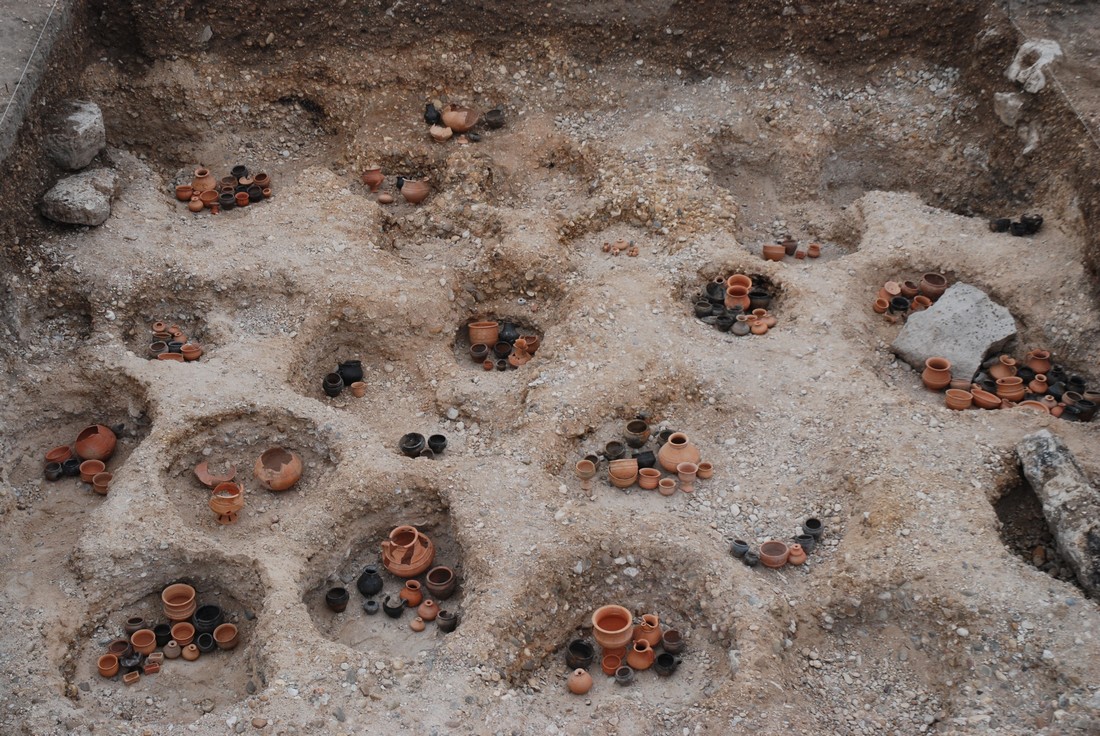
The necropolis of Las Ruedas (translated literally as 'The Wheels') was Pintia>´s cemetery in Vaccean and Roman times. It is located about three hundred meters south of Las Quintanas and jointly shares the natural course of the Vega Stream. The cemetery measures about six hectares and was used for over five hundred years, between the end of 5th century B.C. and the beginning of the 2nd century A.D.
This functional area seems to have the shape of a triangle, with two sides forming a 90º angle following the natural course of the Vega Stream and the third side of the triangle is a man-made trench dug in the southern edge of the necropolis.
Throughout these five centuries incineration was the most performed funerary ritual. The cremated body and cherished items (according to their social condition) were buried together.
")
Cremated bones inside of an funeral urn (tomb 89)
Such items (namely weapons, adornments, needles, brooches, etc.) together with the remaining bones from the cremation process were collected and put inside a ceramic pot (cinerary urn) and then taken to a pit dug in the cemetery area. Here relatives and close friends of the deceased would pay honor by offering food and drink inside proper ceramic-made containers for the journey to the afterlife.
Limestone slabs (some of them were brought from the nearby Pajares Hill) and other perishable items would have marked the tombs for visits, prayers and offerings.
Up to now archaeologists have uncovered more of 300 of these tombs. The most remarkable tombs belonging to Pintian aristocracy like warriors, their wives and daughters. Some of these tombs held over a hundred artefacts and are composed by wealthy contents and diverse range of offerings and personal trousseaux that allow archaeologists to have a more accurate idea of Pintia’s social organization.
The anthropic transformation of the land around the necropolis of Las Ruedas, most of it due to agriculture activity, led on one hand to poor conservation and destruction of the peerless heritage that was still sealed underground; and on the other hand deeply changed what should have been a funerary landscape.
Most of the tombs at Las Ruedas were probably marked with limestone tombstones. In fact, some of those tombstones had monumental sizes marked with circular lines (discoid shaped) that explain where Pintia´s name comes from.
The area of Los Cenizales (literally translated as 'The Ashes') is located near the cemetery and consists of ash sediments, hence the name. Furthermore, this feature also suggests that this area was used, for over 20 to 30 generations, for cremating bodies that were buried in the nearby necropolis.
The sanctuary
Located south of Los Hoyos, in front of the necropolis Las Ruedas and separated from it by the Vega Stream a structure was revealed, only identifiable by aerial photography, difficult to explain.
Square-shaped and measuring 70 meters on each side, which could be interpreted as a negative imprint of a dark-green colour in the tilled earth. In fact, the vegetation growth around it is sparse and the colour is not as sharp, possibly due to the gravel that was removed and pilled in this area.
Additionally the scarcity of archaeological artefacts found on the surface increased the difficulty of interpreting the function of the structure. Nevertheless, considering its proximity to the necropolis it could be a sanctuary, similar to many sanctuaries found all over Europe, but only excavation work will reveal the answers to all these questions.

Aerial photography with photo-remodeling of the sanctuary, stream and path,
together with a model of a Belgian sanctuary
Pajares Hill
The Pajares Hill is located a good two kilometers south of the archaeological site, on isolated and elevated ground. The hill has a flat top that measures no more than a 100 meters by 20 meters and one can still see today, on its western edge, the remaining quarry from which Pintia´s inhabitants would have mined the limestone slabs to mark the tombs. In more recent chronology, the quarry was used it to build the nearby Christian hermitage, now in ruins.

Pajares Hill, back on the right
Even though the surface of this hill is highly eroded, the existence of Vaccean ceramic shards prove that the quarry was inhabited in those days, probably even as a sentry placement, for the city below in the valley.


